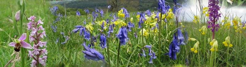
This walk involves descending to the Thames and Severn Canal from Rodborough Common, which runs into Stroud from the East, and then climbing back again (about 675ft, 210m). Although only 6km in length (4m) it is definitely for those who wish to be a little more energetic. However, you will be rewarded by a surprising variety of scene and some interesting wildlife observation opportunities. In Spring there are usually find fine displays of orchids in the open stretches of this Common which is also noted for its invertebrates, including the rather rare "Duke of Burgundy" butterfly. The canal is mainly derelict, but in the process of being restored, working from Stroud eastwards. (The Stroudwater Navigation, which runs into Stroud from the West, has already seen a great deal of restoration out to Eastington.)
We must admit to finding the overgrown channel and banks more interesting from a wildlife viewpoint than the restored sections. This walk covers part of the canal that is next on the schedule for restoration, so do the walk before the changes occur. There are, however, several sections of this old canal that are worth walking, all the way through to beyond the Sapperton tunnel, which we will no doubt document on this website in time.
{mosmap kml='http://minchwildwalks.org.uk/joomla30/images/kml/WalkMap/rodborough_common_to_stroudwater_canal.kml'| overview='1'|mapType='satellite'}
- Start at one of the Rodborough Common car parks. (Of course, if you feel really energetic, you can start from Minchinhampton, as we often do, but add three miles and at least an hour to the walk.)
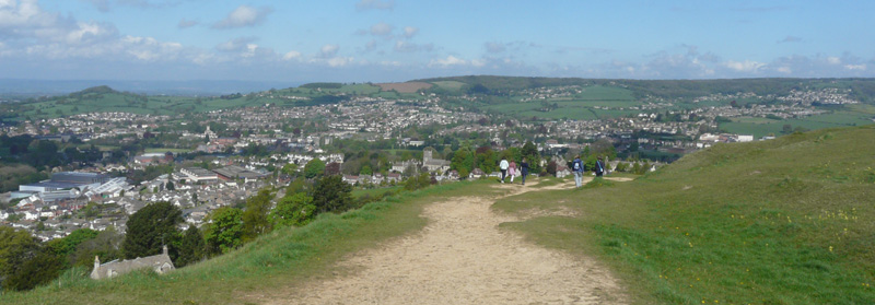
- Head for the western escarpment, for fine views over the Nailsworth valley towards Selsley Common, and beyond the common out to the Severn estuary and the hills of the Forest of Dean and Wales. Kestrels can often be seen hovering over the slopes, soaring on the up-draft from the prevailing westerly winds.
- Turn right and follow one of the tracks to Rodborough Fort.
- Just before you reach the Fort, look for a descending broad track along the side of the hill, heading down to the main road from Stroud.
Descending from Rodborough Fort - Cross the road and look for a public footpath sign pointing along a narrow metalled track between two houses.
- Descend this track to Rodborough playing field.
- Keep to the left hand side of the playing field and follow the hedge to the bottom boundary of the field.
- Pass through a gate into an area of scrub land, and head first right along the boundary and then diagonally down to the left along footpaths. (There are several paths but they will clearly converge at a gateway into a field.
- Continue along the well-walked public footpath down towards the railway viaduct, and pass through a kissing gate.
- At this point go first right and then turn sharp left down to the river. (Ignore the path South East, following the right-hand side of the railway line.)
- Descend to the river footbridge and cross.
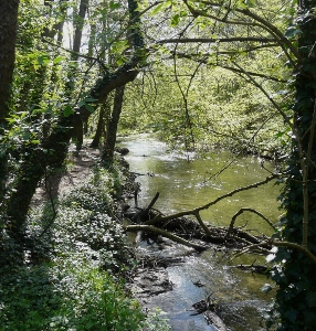
River Frome - In Spring, you may see kingfishers along this stretch: they nest in the bank opposite the foundations of the old mill. Dippers can also usually be seen. (We think they sometimes nest under the bridge.)
- You may well think that it is worth doing a short there-and-back diversion up along the riverside footpath. This is a remarkably attractive water course, given that it is just a step away from the center of Stroud. Note, however, that it does get very muddy in winter.
- Now climb towards the viaduct following the footpath, and then head by the side of the canal basin up to the main road. Cross the canal bridge and then follow the other side of the canal, continuing down to Bowbridge.
- N.B. As of January 2016, the canal footpath exit onto Butterrow Hill at Bowbridge is temporarily closed to walkers, because of the reconstruction work on the road bridge. Follow the diversion along the road to Bowbridge.
- Cross the road and descend back to the canal, and follow the path past the reconstructed lock, until you see a white metal latticework footbridge crossing the canal. Take this.
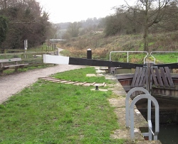
Cross by the bridge in the background. - Ascend to the railway line and cross carefully. This is the main line to London from Cheltenham and Gloucester so take great care: stop, look, listen!
- Cross the style into the field and ascend diagonally left up the hill.
- Emerge from the field by a kissing gate onto a road (Monserrat) and turn left and then after a few meters cross the road and take the broad track (known as Hodsoll Path) up through the trees to the left of the house.
- A steady climb along this track brings you onto common land near Winstone's Ice Cream Factory.
- Cross the Stroud-to-Cirencester road close to the "Bear of Rodborough" and take the track above Bear Hill leading back to round to the western edge of Rodborough Common.
- Follow this edge. There are several tracks that lead diagonally back to the car parks on the main road. You can extend the walk, or cut it short and return to the car according to taste and prevailing weather.
Photographs taken along the canal can be found in the Gallery.