A circular walk from Minchinhampton, descending to the Golden Valley, then climbing through the fine woodland west of the Toadsmoor Road, to head for Nether Lypiatt Manor. Return is via Bowbridge and Rodborough Common. The total length is 12km/7.5m and requiring 400m/1300' of climb. You should allow at least 3 hours, but it is worth taking a picnic and a bit more time.
This is a longer walk, and certainly requires a bit more commitment. You are strongly advised to take your own map, preferably the 1:25000 "Explorer" (168), and know how to use it, because the tracks in the woodland along the Toadsmoor Valley can be confusing - though most end up somewhere reasonably sensible in the end. Please note that the track in the Google map was not created by walking the route with a GPS and particularly in the woodland it may not lie exactly on the paths.
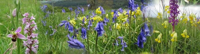
The walk, in my opinion, is best in Spring and Autumn, when you either have spring flowers or autumn colours.
{mosmap kml='http://minchwildwalks.org.uk/joomla30/images/kml/WalkMap/minchinhamptontonetherlypiatt.kml'| overview='1'|mapType='satellite'}
- We nominally start from Minchinhampton's Bell Lane Car Park - but anywhere in Minchinhampton will do.
- Walk towards the Cirencester Road, to the junction where Butt Street joins from Minchinhampton.
- Cross and take the minor road (do not enter The Tynings).
- After about 100m, follow the footpath sign on the left over a style into a small field used by a firewood supplier.
- Exit the field by the stone style, and then through the gate immediately opposite, along the track between the house on the left and a field on the right.
- At the T-junction with a left-right track above Besbury Common, you can cross and make the steepish descent straight ahead along the right of way.
- However, you may prefer to turn left for an easier descent to the road after a short distance.
- Descend onto the road at the lower side of Besbury Common. (If necessary, continue until the track you are on meets this road.)
- Turn right along this road until it comes to an end and take the style into the field.
- The track you need trends diagonally left away from the style over the rough grass of the field. Look for a wooden post marking the approximate route.
- The path splits here, one trending right along the contour (ignore this). You need a descending track which can be difficult to find on the ground when the grass is tall in summer. It tends to lie over towards the line of trees on the right.
- Continue until you reach a boundary crossing at the bottom going into woodland, with a track descending to the right.
- This takes you to a gate onto Knapp Lane. Turn left until you reach the canal and descend to the towpath. It has to be said that this is one of the less interested bits of the canal from a wildlife viewpoint - but it does not last very long.
- Follow the towpath until you go under the railway and then look for a canal crossing which very quickly gets you out onto the A419, Stroud Cirencester Road.
- Cross this busy road carefully and directly across look for a steeply climbing metaled footpath and continue climbing until you emerge onto the minor road between the Toadmoor Road and Brimscombe almost directly facing another minor road going uphill to Lower Bourn and Quarhouses.
- Follow this road (still climbing steeply!) until the road bends left. Look for a footpath sign along a track going straight ahead, along a farm track. (Two tracks diverge here - make sure you are on the one that continues straight and level.)
- Continue along the track until you have Newland's Farm just below you. A footpath branches straight up the hill to the left (a possible alternative route) but you should continue straight on, just above the farm, and continue into fine beach woodland.
- Follow this track until you reach a fence straight ahead. Cross this by the style on the lower boundary just to your right, finding yourself on a broad unmade track coming up from Toadsmoor (marked as a "route with public access" on the Explorer map). This track, which eventually exits on the minor road between Quarhouses and Nether Lypiatt, is a viable route variation, with easy navigation. However, after a very short distance along this way, I prefer to take the broad track that branches to the right and continues through to Hales Wood more-or-less on the level.
- There are many possible minor variations here, along a number of rights-of-way through the woodland which all seem to converge on Nether Lypiatt Manor. In woodland it is often the case that paths on the ground do not always coincide exactly with rights-of-way, because the most used routes may be those created for woodland management. The suggested route seems to me to be easy to follow while staying on a path that is certainly a right-of-way. However, the essential idea is to get to the vicinity of the Manor, and as long as you keep climbing you are likely to emerge in that area on one of the rights-of-way along the upper boundary of the woodland.
- Here, just before the track descends down to the right towards the valley road, look for a way-marked path taking a sharp left up the hill. You eventually reach a path T-junction. Either way works, but I suggest turn left until you join one of the other paths coming up the hill. Turn right uphill to emerge into a field below the Manor. Going left along the lower field boundary brings you into an area laid out as gallops. Turn left towards the road.
- On the road go right until on the right you see the entrance to Claypits Lane, and "The Limekilns".
- Follow this track as far as it goes, finally descending into a belt of trees.
- Turn left along the track through the trees, and eventually meet a path descending west towards Bowbridge. The next part of the descent is surprisingly pleasant, with good views across to Rodborough Common. One might be tempted to pause for a picnic along here after a late start. (In summer, I prefer an early start - before it gets too warm - and getting the final climb under my belt before pausing for a break.)
- Continue a descent to a stream. Several paths join here. All but one climb. You want the one that does not do so, bearing SW across a metal bridge over the stream towards Bowbridge.
- Exit out onto Gunhouse Lane, and then London Road at Bowbridge.
- Cross the main road and turn into Butterrow Hill, over the canal bridge and past the entrance to the Bowbridge veterinary clinic.
- Just before the road turns right, turn left into a side-shoot of Butterrow Hill along the line of the railway and look for a tunnel.
- From here, you just keep looking for footpaths going up the hill whenever you emerge onto a road, first when crossing Butterrow Hill again, almost straight across, then, when crossing Rodborough Lane, first turn left then diagonally right up the hill along a minor road.
- When you find the open land of Rodborough Common in front of you, take the well-used track up the hill side.
- If you have started early enough, anywhere on Rodborough Common would be an excellent picnic spot. We have found numbers of bee orchids on this side of the Common. The views over the valley are good and it is much quieter than the western side of the Common.
- From here there are many alternative routes back to Minchinhampton. We suggest climbing to the main road rising from Stroud through Rodborough, crossing at one of the car parks and then and heading for the western escarpment of the Common, and then working round to the Bear of Rodborough.
- Take the minor road below the Bear, and continue until you find the second footpath sign on the left, pointing through the gate into a cottage garden. (The first footpath sign on the left points up a broad track - ignore it.)
- You could also continue another few hundred meters up the road and look for a broad, but rough track on the left leading up to the Common.
- Follow the path through until you emerge on Minchinhampton Common.
- Again, you can choose which side of the Common you follow. We suggest crossing to the dew-pond, then heading for Brimscombe Hill, crossing and returning to Bell Lane by the shortest route.