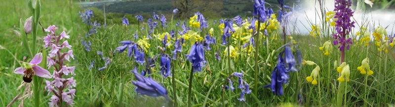
Rudge Hill is also probably better known as Edge Common (and registered as an SSSI under this name). The reserve was renamed when it became part of the Cotswold Commons and Beach Woods National Nature Reserve. The walk start from the Leisure Centre car park in Stroud and surprisingly quickly leaves the town behind to follow a low ridge up towards Painswick. After crossing meadow and arable farm land with good views over towards Whiteshill and Randwick, we join the Cotswold way, coming south from Painswick and climb through vary varied woodland and farmland to Edge Common - now also designated as "Rudge Hill Nature Reserve". In Spring and early Summer you can get fine displays of orchids on the unimproved grassland, plus excellent views back towards Painswick.
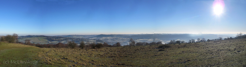
Painswick from Edge Common
This is a longer walk of about 11 km/7m with a climb of 280m/900', so although I sometimes do it as a morning walk, taking about 2.5 hours at a steady pace, a later start and leisurly progress gives a good excuse for a picnic - and Edge Common is the best place to pause. After Edge Common, we have a short stretch through classic Cotswold Beach woods and then descend over meadows and woodland to join the top of Stratford Park. There are a couple of minor variation that can be used to give a bit of variety on later repetitions. (In fact, there are many potential variation, only some of which I have yet explored. All the ones I have tried have their own merits.)
The map also shows a long 6km/3.5m extension that continues along the Cotswold Way round to Haresfield Beacon, and turns the walk into a definite full-day affair - probably with lunch on Harefield Beacon - which makes a very fine round with a lot of variety for those of you who are regular and reasonably fit walkers. (I have done even longer variations on a fresh summer day when it seemed a shame to finish the walk: on days like that I sometimes take a map out with only the vaguest plan for the walk, other than a general direction of travel, and trying some new combination of paths. I then carry on - making it up as I go - until my legs tell me it is time to find my way home. This long extension continues to follow the Cotswold Way on to the woods above Randwick, and then working my way back to Stroud across the valley. If you have the fitness and competence to tackle this last variation you do not need me to tell you how to plan the route.)
{mosmap kml='http://minchwildwalks.org.uk/joomla30/images/kml/WalkMap/stroudtoedgecommon.kml'| overview='1'|mapType='satellite'}
- After parking in the Stroud Leisure Centre car park, walk towards the Museum in the Park and then down and out onto Stratford road, and into Beeches Green towards the town centre.
- Cross at the pedestrian crossing in Beeches Green, and take the rising footpath immediately on the other side into Folly Lane and turn immediately right into Lovedays Mead.
- Follow Lovedays Mead until it enteres a private road and then ends at a gate with a footpath sign.
- Follow the footpath which rises along the top of a low ridge. By the time you reach the second field Stroud is hardly visible and you feel in open country.
- The path goes diagonally across the third field to emerge on Painswick Old Road, which you cross and immediately cross the style on the opposite side of the road, again going diagonally across the field towards Hammond's Farm.
- On exit from the field follow a short farm track to meet a farm road running left-to-right. Turn left and after about 30 m look for a footpath sign on the other side of the road.
- Take the track along the left-hand of the field boundary, across a style into a short over-grown corner (take stick to deal with nettles in high Summer!) across another style and again follow the field boundary until you emerge on Wades Lane.
- Turn left and after about 50m take the track leaving the road on the right, crossing a couple of fields to emerge by a house onto Pincot Lane.
- The route onwards is clear, taking a style visible across the right slightly to the right.
- Continue over the field then down into a wooded dell with a stream, climbing out the other side and heading for a large house ahead, and a gate just to its left.
- Continue in the same direction (slightly east of north) out along the entrance road to the house until you see a track branching off to the left. (Ignore the kissing-gate into the field - there is no right of way here.)
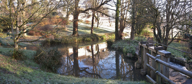
- Descend along the track to King's Mill, along the side of the mill stream.
- There will be a great temptation to take the marked path over the weir footbridge. Not today - but I do recommend the variation along here that heads towards Painswick where you can either join the Cotswold Way further up where it comes out of the town, or even skirt round the outside of the town and the boundary of Painswick Rococo Gardens and loop round to Edge Farm and back to Edge Common.
- Our route goes past the mill pool, emerging onto King's Mill Lane.
- Turn right and then after the first house on the left look for a footpath sign pointing just to the right of the garden's yew hedge.
- This climbs to the A46, which you cross and look for another public footpath sign just to the right.
- Follow the left field boundary above the wooded valley of Wash Brook, though into the next field, join the Cotswold Way coming in from the right, and follow on to Washbrook Farm.
- Follow the way marks round the outside of the farm circling round to the left and head up along a farm track until you see the clearly way-marked access to the Cotwold Way that continues along the attractively wooded valley of Wash Brook, above the stream.
- When you emerge into the next field head for a wooden way-mark post at the top of the slope.
- Here you can choose vary to route by going left, heading for a tree standing above the field hedge to find the style into the next field and a path continuing until you emerge on Edge Village Green. Take the road up to the left onto the A4173 Stroud-Gloucester road and walk left until on the opposite side of the road you see a footpath sign pointing up the drive of a house. Follow the track to the northern top corner of Edge Common. This variation has gentler gradients than the true Cotswold Way and is not without its own attractions.
- The Cotswold Way goes through the gate behind the waymarking post, left along the field boundary and out on Jenkin's Lane where you turn right and climb steeply up to the A4173 Stroud-Gloucester road.
- Turn right along the main road ignoring the footpath sign immediately opposite (which gives a steep climb to the Common missing out some of the nicer bits). Immediately after passing the Edgemoor Pub you will see the Cotswold Way sign on the opposite side of the road. This takes you up to the top boundary of Edge Common by an easy and attractive route.
- Once we reach the quarry at the top, we depart from the Cotswold Way (unless you want to do a long extension round by Harefield Beacon - worth doing but adding at least an hour to the walk).
- The Harefield Beacon extension continues along the Cotswold Way to the Beacon and then right round to Standish Wood, and only leaves it when it takes a turn from east-of-south to west-of-south. You need to stay close to the north-eastern boundary of the woodland following the path that branches due east to emerge on the road at Stoneridge Farm. Turn left onto the road down to Randwick to meet the Main Road (actually called Main Road) and then across to Haresfield Farm and down the footpath to rejoin our route the other side of the style at the bottom. (I have followed the Cotswold Way right down to Randwick on one occasion - but that is another long variation.)
- On Edge Common, our highest point, we pause for the views and maybe a picnic before following the top boundary of the reserve (in the Stroud direction) to the south west corner where we can emerge onto the road and cross to the woodland on the other side, turning left onto the track.
- This is classic Cotswold beach woodland, and we follow the track south staying close to the road so we can leave the wood and and cross the road again to enter the large field that runs up to Haresfield Farm.
- We now need to take the path that trends towards the left-hand wooded field boundary, heading for a white post marking the style that gives access to the woodland. The only other exit from this field is a style up by Haresfield Farm itself.
- Once in the woodland we follow this boundary fromthe other side into a field until we meet the track coming down from Haresfield Farm. At this point look for a style given access to woodland ahead.
- In the woodland ignore the well-used track staying by the upper boundary on your right and start descending along the bottom of the gully to your left. (The path can be well covered with leaves in autumn - almost invisible - and you will need to look out for buried stones from the wall that used to run along the side of the path.)
- At the bottom of the gully, turn right, climb the style by the house, and turn along the fenced track below the houses.
- The path heads for a farm passing it on the right, but once past the farm you need to look for a path that descends across a small field down to the farm access track.
- Continue along this access track until it joins Field Road coming in from the right, and you see a narrow track between fences going straight ahead, descending south-east in the general direction of Kitesnest Farm.
- At Slad Cottage turn right along its access road and continue right turning back up the Whiteshill towards the church.
- Look for a footpath sign on the left into the field running up to the church and follow the left hand field boundary towards Callowell Farm.
- From here it is just a matter of going through the farm and turning left to the access track down to Salmon Springs.
- After emerging on the A46 road and heading right towards Stroud, after about 50m take the gate into the top end of Stratford Park and work back round to the Museum and the car park by whatever paths take your fancy.