This walk involves a short drive to Woodchester as a starting point, and a climb to Selsley Common, another SSSI noted for both flora and fauna.
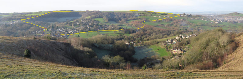
The route to Selsley seen from Rodborough Common
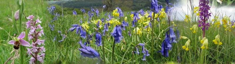
Park close to the parish church of St Mary's where there is usually space at the roadside. The walk involves an initial steep climb up to Selsley Common over fields and through woodland, then a short strole along the western escarpment (the region identified as the SSSI), followed by a gentle descent back to Woodchester. The best time for this walk is Spring, to take in the orchids on the western slopes of Selsley Common. Overall, it involves about 5km (3 miles) of walking and 160m (500') of climbing. A regular walker could manage it in an hour and a half, but it is better to take a bit of time to enjoy the view from the Common.
{mosmap kml='http://minchwildwalks.org.uk/joomla30/images/kml/WalkMap/woodchestertoselsleycommon.kml'| overview='1'|mapType='satellite'}
- From the church head west towards the high ground and look for a footpath sign on the left, just where Church Road takes a right-angle bend to the right.
- After entering the footpath, turn right. (Straight on takes you the South Woodchester.)
- Initially there is a short descent across a small bridge then a climb up the hill on a fairly clear route.
- Exit onto the top of Laggar Lane and cross to take the style immediately opposite.
- Climb the steep hill towards the top of the field. You will need to trend a little to the left to find the exit from this field in a top corner.
- Now turn right up the road and after a short distance enter woodland. You then need to take the broad climbing track that follows the right-hand boundary of the woodland.
- This eventually emerges into a sloping field. Again keep to the right-hand boundary unless diverted by electric fences which the owners frequently use to prevent horses going into very boggy areas. (You don't want to go there either!).
- Cross styles and eventually emerge onto the B4066 road along Selsley Common.
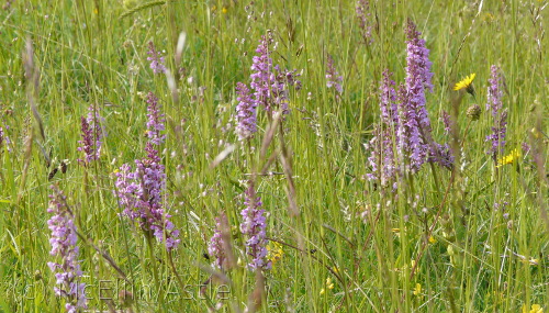
- The best route here is to work your way over to the western escarpment. Orchids seem to favour this slope and fragrant orchids in particular can sometimes be seen in spectacular profusion on the slopes.
- After following the escarpment round, you will eventually start trending north east and find yourself on a descending slope. You are aiming to hit the B4066 again, where "The Grove" crosses to Selsley village and "Water Lane" also joins from the other side.
- Cross the B4066 and follow Water Lane. Ignore the first footpath sign on the left early on and continue to the second left pointing sign.
- Cross the style and descend along the right-hand boundary of the field until you see a style that lets you cross into the woodland. Descend along the track.
- Unfortunately, at the lowest point just before entering a field, this track becomes confined by fences on either side and also crosses a spring line, creating a short muddy stretch even in Summer, and an exceedingly muddy five meters or so after a wet season. However, even at its worst, it is just about possible, normally, to pick your way along one fence line emerging with muddy boots but not having had to wade ankle deep.
- At the upper style on Water Lane, you could choose to continue along the lane (which eventually become an unmetaled track) until it emerges into Woodchester. Turn left onto Selsley Road through Woodchester and then right into Church Lane back to the car.
- Our recommended route (after the muddy stretch) crosses a field and emerges onto a continuation of Church Lane. Turn right and follow until you see a footpath sign on the left. Follow this round the boundary of the houses until is emerges onto Selsley Road, turn right and then left into Southfield Road and then right again into Church Lane.